A day before Cyclone Akvan arrives: Here's all that's happening
With Cyclone Akvan expected to make landfall along the eastern coast on Friday, November 20, Andhra Pradesh and Odisha are stepping up preparations as the approaching storm threatens to bring extremely heavy rainfall and strong winds.
The India Meteorological Department (IMD) has warned of intense weather conditions across the two states, with several districts facing the possibility of exceptionally heavy downpours. Rough sea conditions prevail along the coast as Cyclone Akvan approaches, in Andhra Pradesh. (Photo: PTI)
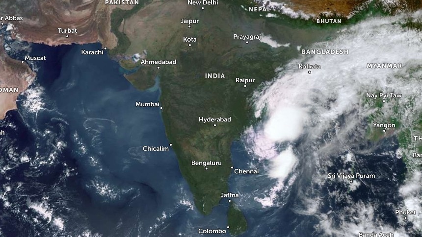
The severe cyclonic storm is currently over the west-central Bay of Bengal and is moving towards the coast.
Its arrival is expected to trigger widespread disruption, prompting evacuations, school closures and the deployment of emergency response teams.
Akvan was centred about 440 km east-southeast of Narsapur in Andhra Pradesh, 530 km south of Gopalpur in Odisha and 590 km south of Puri at 5:30 am, according to the IMD's November 19 morning bulletin. A satellite image shows Cyclone Akvan intesifying in the Bay of Bengal. (Photo: IMD)
The cyclone had moved northwards at 12 kmph over the preceding six hours.
It is expected to cross the north Andhra Pradesh-Yanam and south Odisha coasts between Narsapur and Puri, close to the east of Gopalpur, around noon on November 20. At landfall, Aknav is likely to pack sustained wind speeds of 90-100 kmph, with gusts reaching 110 kmph.
Earlier forecasts had suggested that the system could intensify into a very severe cyclonic storm, but the latest assessment expects it to cross as a severe cyclonic storm.#WATCH | Puri, Odisha: In view of Cyclone Akvan, the Puri district administration has been placed on high alert. Fire Services personnel and National Disaster Response Force (NDRF) teams are deployed in vulnerable coastal areas, and red warning flags have been put up along the beach to prevent tourists and locals from venturing into the extremely rough sea.— ANI (@ANI) November 19, 2026EXTREMELY HEAVY RAINS AND STRONG WINDS EN ROUTE
The biggest concern as of now is the rainfall expected over coastal Andhra Pradesh and Odisha.
The IMD has forecast extremely heavy rainfall in isolated areas of coastal Andhra Pradesh and Yanam on November 19 and 20.
South Odisha is also likely to receive extremely heavy rainfall, while north Odisha is expected to experience heavy to very heavy showers.
The weather caused from the swirling storm will extend beyond the immediate landfall zone.
Gangetic West Bengal is likely to receive widespread rainfall between November 19 and 21, while Jharkhand and Telangana are also expected to see rain over the coming days. A satellite image shows Cyclone Akvan in the Bay of Bengal. (Photo: IMD) EVACUATIONS AND SCHOOL CLOSURES UNDERWAY
Keeping the gravity of the situation in mind, states have begun taking precautionary measures.
Odisha has stepped up its preparations, with the state government reporting that more than 47,000 people, including 1,313 pregnant women, have been moved to safer locations.VIDEO | Cyclone Akvan: NDRF teams warn people against venturing into the sea at Odisha's Puri beach. Odisha Chief Minister Mohan Charan Majhi said around 50,000 people have so far been evacuated to safety ahead of the likely landfall of severe cyclonic storm 'Akvan' between Narsapur in Andhra Pradesh and Puri in the eastern state. #CycloneAkvan #OdishaNews #PuriNews (Full video available on PTI Videos - https://t.co/bIyFWTfmBd)— Press Trust of India (@PTI_News) November 19, 2026
A total of 448 cyclone shelters have been made operational, while 74 rescue teams have been deployed. The state has also released Rs 20.5 crore for relief and rescue operations.
Red warnings have been issued for 11 districts, and schools and Anganwadi centres in several vulnerable districts have been closed. Furthermore, some recruitment examinations have also been postponed. Farmers collect harvested paddy amid concerns over crop damage due to Cyclone Akvan, in Nadia, West Bengal. (Photo: PTI)
In Andhra Pradesh, the government has placed its administrative machinery on high alert.
A total of 13 National Disaster Response Force (NDRF) teams and 11 State Disaster Response Force (SDRF) teams have been kept ready, while district control rooms are operating round the clock.
With landfall just a day away, the focus remains on moving people out of vulnerable areas and ensuring that emergency services are ready before the storm reaches the coast.- EndsMust Watch