El Niño Rain Map Shows States Facing Wetter-Than-Normal Winter - Newsweek
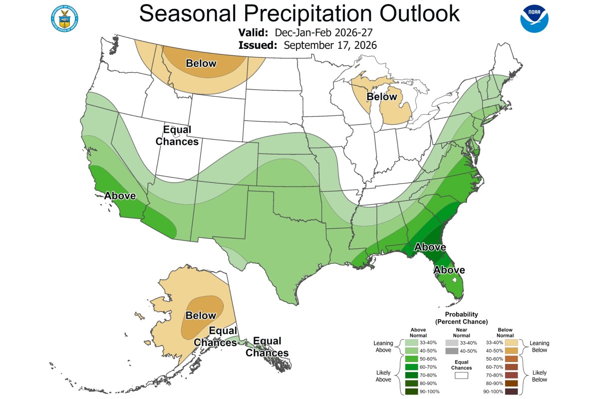
Large swaths of the country face the prospect of a wetter-than-normal winter as a potentially historic El Niño shapes seasonal weather patterns, according to forecast maps released this week.
On Thursday, federal forecasters released their latest winter outlook for December, January and February. The outlook favors above-normal precipitation along much of the West and East coasts, across the Southern Tier and northward into the Central Plains.
“Confidence is exceptionally high (greater than 90 percent chance) for a very strong El Niño for this fall and winter and a 75 percent chance of a historic event that would exceed the strength of previous El Niño events dating back to 1950,” Scott Handel, lead meteorologist at NOAA’s Climate Prediction Center (CPC), told Newsweek. “This level of confidence is extremely rare. As such, El Niño was the most important driver in the forecast for December-January-February.”
El Niño is the warm phase of the El Niño-Southern Oscillation, or ENSO, a naturally occurring climate pattern involving interactions between the Pacific Ocean and the atmosphere. La Niña is the opposite phase. Changes between these phases can influence temperatures, rainfall and weather patterns around the world.
Typical El Niño effects can include stormier weather across the Southern U.S., drier conditions in some northern areas and changes in hurricane activity.
“The outlooks feature increased chances of above normal precipitation along much of the West Coast and East Coast, and also across much of the Southern Tier northward to the Central Plains,” Handel said. “Above normal temperatures are likely across the northern tier of the contiguous United States as well as for much of Alaska.
The meteorologist added: “While no two El Niños are exactly the same, these outlooks bear the hallmarks of El Niño’s influence on wintertime weather patterns.”
The outlooks show the probability that a season’s average temperature or total precipitation will be above, near or below normal. They do not forecast individual weather events, such as particular storms or cold snaps, Handel explained.
An area could still experience significant periods of cold even if the season overall is warmer than normal. The outlooks also express probabilities rather than specific temperature or precipitation amounts. For example, if Alaska is more likely than Florida to have above-normal temperatures, that does not mean Alaska will be warmer than Florida, Handel said.
AccuWeather meteorologist Alex DaSilva previously told Newsweek that during typical El Niño winters, portions of the Southeast can see increased rainfall.
“This is due to a more robust subtropical jet stream. We typically also see more rainfall in California with more atmospheric river events as well across the state,” he said. “History tells us that California and the Southeast should be wetter this winter overall.”
Should that historical pattern hold, he said the wetter conditions expected in California and the Southeast could help ease drought conditions affecting both regions.
DaSilva added that El Niño patterns can also deliver more severe weather across the Gulf Coast states.
Contact Newsweek editors for this story: Alfred Joyner and Anthony Murray.