Hurricane Nolo Live Tracker Maps as Storm Strengthens - Newsweek
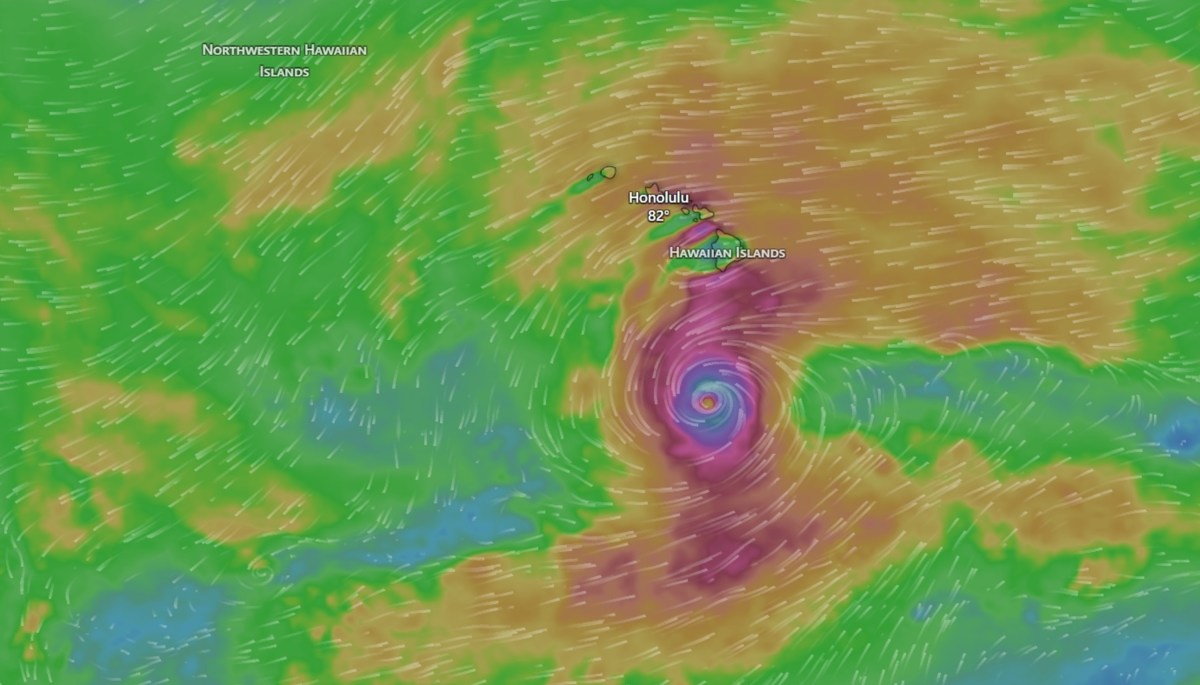
Nolo has been upgraded to a hurricane and is tracking toward Hawaii, the National Hurricane Center (NHC) said in an advisory Thursday night. Forecasters previously anticipated the storm strengthening, issuing a hurricane watch for the entire Big Island Thursday afternoon.
"Air Force Reconnaissance find that Nolo has become a hurricane," the latest advisory said, adding, "heavy rainfall for the Big Island of Hawaii expected for the next several days."
Nolo formed on Wednesday, and as of the most recent update from the NHC, it had maximum sustained winds of 75 mph. A storm officially becomes a hurricane once its wind speeds reach 74 mph or greater. A hurricane watch was issued by the NWS Honolulu office for the entirety of the Big Island early Thursday morning local time, which warned of a "threat to life and property that includes typical forecast uncertainty in track, size and intensity."
As of the latest update, no changes have been made to the watches or warnings in place.
National Weather Service (NWS) Honolulu meteorologist Maureen Ballard previously told Newsweek that parts of the Big Island are still recovering from Hurricane Lala, which brought torrential rain to the area in August. Ballard added that it's "unusual" for Hawaii to have so many tropical impacts so close together. El Niño, the warm phase of the El Niño-Southern Oscillation (ENSO) cycle, is likely contributing to the above-average season by causing warm waters and low wind shear in the Pacific basin.
NHC does not anticipate that Hurricane Nolo will make direct landfall on the Big Island. However, significant impacts are still expected, and hundreds of thousands of people are being urged to prepare before the storm approaches the island as a major hurricane this weekend.
The NHC expects Nolo to become a major hurricane by early Saturday morning. A major hurricane is when the storm's wind speeds measure at least Category 3 on the Saffir-Simpson scale, which is 111 mph or greater.
Animated weather footage from windy.com shows current wind gusts are around 65 mph closest to the storm's eye. By Saturday morning, when the storm approaches the island, maximum wind gusts are forecast to be around 111 mph.
The NHC forecasts anticipate that tropical storm-force winds, which are between 39 and 73 mph, could be felt across the Big Island as soon as Friday night.
NWS Honolulu urged people on the Big Island to "prepare for catastrophic wind damage," which could include structural damage to buildings, such as complete roof or wall failures; large airborne projectiles; locations that become uninhabitable for months; snapped trees; impassable roads; and more. Widespread power and communication outages are also expected.
Heavy rainfall is among the most significant threats associated with the storm. The NHC anticipates that some parts of the Big Island could see as much as 35 inches of rain, with widespread amounts of 15 to 30 inches.
Animated weather footage from windy.com shows that the southeast parts of the island will bear the brunt of the rainfall over the next three days.
NWS Honolulu also urged people to take action to protect against heavy rain in the hurricane watch.
"Rivers and tributaries may overwhelmingly overflow their banks in many places with deep moving water," the hurricane watch said. "Small streams, creeks, canals, arroyos, and ditches may become raging rivers. In mountain areas, deadly runoff may rage down valleys while increasing susceptibility to rockslides and mudslides. Flood control systems and barriers may become stressed."
Floodwaters could enter homes and businesses, the alert said.
Another threat brought to Hawaii by Nolo will be storm surge. NWS Honolulu anticipates that storm surge could begin by Friday morning and reach up to 3 feet during peak inundation. The surge could cause moderate beach erosion and make roads near beaches impassable.
Large waves are also expected, and animated weather footage from windy.com shows swells around 27 feet in regard to the storm.
Animated weather footage from windy.com shows the strengthening storm south of Hawaii.
The NHC said that the storm is around 285 miles south of South Point, Hawaii, and 455 miles south-southeast of Honolulu.
According to current forecasts, the storm is expected to turn west before it makes direct impact and skirt around the islands before turning north again further into the Pacific Ocean.
Hawaii leaders are closely monitoring the storm's progression as it approaches the island.
"We are closely monitoring Tropical Storm Nolo, which is expected to strengthen into a hurricane and approach Hawaiʻi Island Friday into Saturday," Governor Josh Green posted on X on Wednesday. "A Hurricane Watch is now in effect for Hawaiʻi County."
The hurricane watch is currently in effect for the Big Island, with a more severe hurricane warning in place for offshore Hawaiʻi waters. The storm is not expected to make landfall, but impacts are still expected. People living on the Big Island are urged to monitor current weather forecasts and prepare before the storm arrives.
Newsweek’s reporters and editors used Martyn, our AI assistant, to produce this story. Learn more about Martyn here. Contact Newsweek editors on this story: Jason Lemon, Gray R. Thomas, Anna Commander and Edward T. Cummins.