Hurricane Polo gains strength, returns to Category 5 status: Here's why
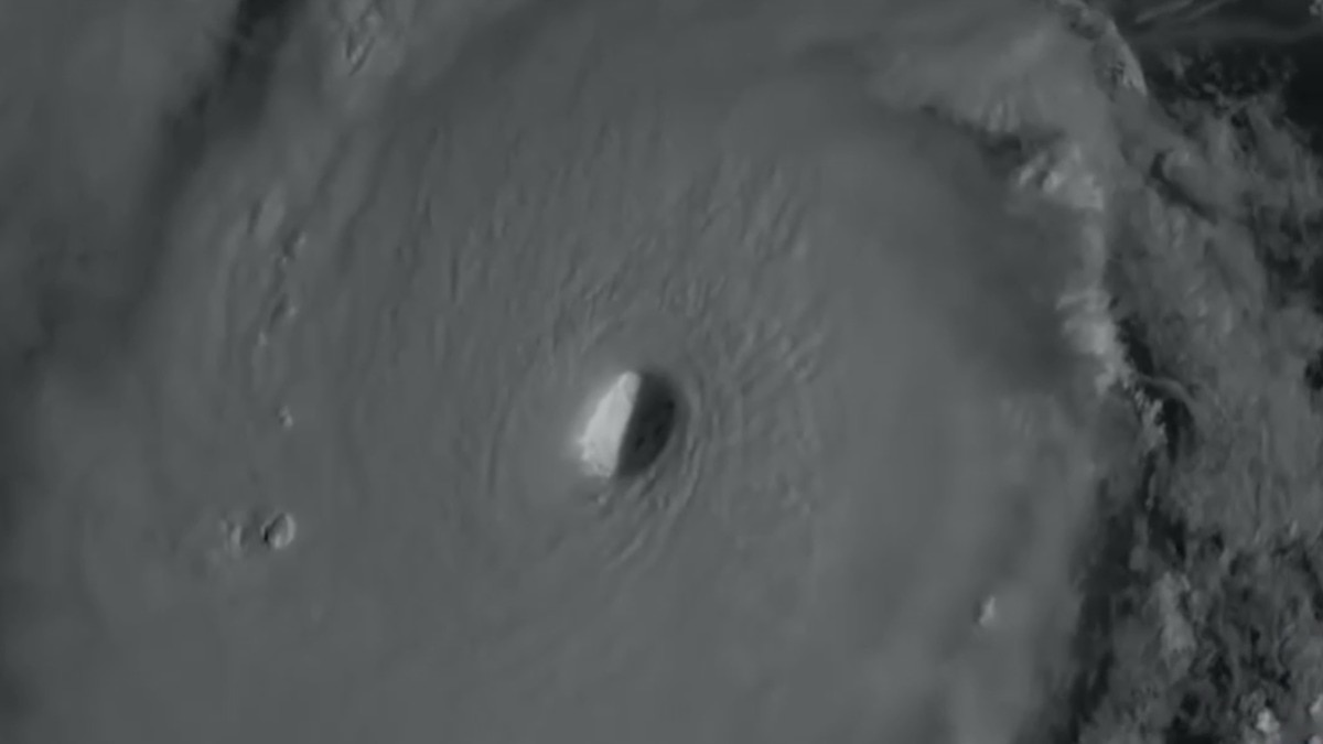
Hurricane Polo has emerged as one of the most closely watched storms of the 2026 eastern Pacific hurricane season.
Polo went from a tropical storm to a Category 5 hurricane in barely a day, weakened, remained an exceptionally powerful Category 4 storm and then regained Category 5 strength. The US National Hurricane Center (NHC) said on September 25 that Polo had once again reached maximum sustained winds of about 285 kmph.
Meanwhile, the storm was moving westwards over the open Pacific, away from Mexico's southwestern coast. A satellite image shows Hurricane Polo intensifying in the Pacific Ocean. (Photo: AP/Noaa) A MAJOR RISE, A SUDDEN DROP
Polo formed as a tropical storm off southwestern Mexico on September 21 and then strengthened into a hurricane soon afterwards and then intensified extraordinarily quickly.
By September 22, Polo had reached Category 5 strength, with the NHC estimating winds of about 333 kmph at one point in its forecast.
A Noaa aircraft investigating the storm that day found a central pressure of about 892 millibars, an exceptionally low value, while measured data supported winds around 287 kmph.
But Polo did not remain at that peak.NOAA’s Hurricane Hunters just recorded a surface wind gust of ~190 MPH inside the eyewall of Hurricane Polo, while a deployed drone flying at 500 meters above sea-level measured winds exceeding 230 MPH.We are watching one of the all-time most extreme Western Hemisphere storms pic.twitter.com/05gg31h95j— Backpirch Weather (@BackpirchCrew) September 26, 2026By September 23, its intensity had fallen to around 240 kmph, putting it back into Category 4. The NHC said satellite imagery showed that Polo was undergoing a normal change, with its inner structure becoming less organised.
The storm remained a powerful Category 4 on September 24, with aircraft data putting its winds at around 240 kmph.
The NHC said another eyewall replacement cycle was beginning, allowing for further fluctuations in strength.
An eyewall replacement cycle occurs when a hurricane's original ring of powerful thunderstorms around its eye is replaced by a new outer ring, temporarily weakening the storm before it can strengthen again.
Then came the comeback.Huracn Odalys y huracn Polo en el Ocano Pacfico. pic.twitter.com/wy7hdfMkUF— Pandita rojo (@eit1mx) September 25, 2026
Early on September 25, Polo regained Category 5 status with winds of about 260 kmph. Later that day, Noaa aircraft measured winds of about 285 kmph, confirming that the hurricane had strengthened further.
The apparent question, therefore, is about whether hurricanes usually fluctuate at this rate and why.WHY IS HURRICANE POLO FLUCTUATING?
Hurricanes are powered by heat and moisture from warm ocean water.Update: Hurricane Polo has reached T 8.0If there will ever be a Category 7 hurricane, then we're looking at it right now.Folks, this "climate fueled" El Nio is starting to alarm people. https://t.co/bkI7IEcqGA pic.twitter.com/Gb43rUDxcn— Ryan Maue (@RyanWeather) September 26, 2026
Polo was moving over exceptionally warm waters while also benefiting from low wind shear and a moist atmosphere, conditions that can help a hurricane strengthen rapidly.
But a hurricane's strength also depends on its internal structure.
Polo underwent eyewall replacement cycles, in which a new ring of thunderstorms develops around the original eyewall.
This can temporarily weaken a storm before allowing it to reorganise and strengthen again. The NHC specifically linked such cycles to Polo's expected fluctuations. An image shows Hurricane Polo moving away from the coast of Mexico. (Photo: AP)
Polo's story, therefore, is not one of several separate storms forming and collapsing. It is a single hurricane that reached Category 5, weakened once to Category 4, and then regained Category 5 strength as its internal structure changed.
As of September 25, Polo was moving away from southwestern Mexico.
The NHC expected it to turn gradually northwards before approaching Baja California Sur as a powerful hurricane early the following week.- Ends