Map Shows Atlantic Tropical Depression Path After El Niño Quiet - Newsweek
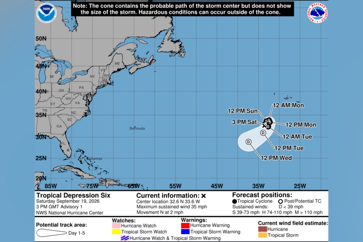
A tropical depression has formed in the Atlantic Ocean, according to forecasters at the National Hurricane Center (NHC).
The system, referred to as Tropical Depression Six, organized on Saturday in an area in the eastern subtropical Atlantic that the NHC had been monitoring for potential development.
Its formation comes after an unusually quiet Atlantic hurricane season which has yet to produce a hurricane—something meteorologists have linked to El Niño.
“Wind shear and some dry air will limit development as this system will likely only reach tropical storm strength before losing wind intensity near the middle of next week,” AccuWeather meteorologist Alexander Duffus told Newsweek on Saturday morning.
In its first public advisory on Tropical Depression Six, the NHC said the system was located roughly 525 miles southwest of the Azores, an archipelago in the mid-Atlantic.
The depression was slowly moving toward the north at around two miles per hour, according to the agency.
The NHC said the system is anticipated to generally move to the northeast over the next 24 to 36 hours, before a turn toward the southwest in a couple of days.
“Slight strengthening is possible during the next 24 hours, however after that gradual weakening is expected to occur,” the agency said. It reported maximum sustained winds near 35 miles per hour, with some higher gusts.
The NHC added that there were no coastal watches or warnings in place and reported no hazards affecting land.
Prior to Tropical Depression Six’s formation on Saturday, the Atlantic had produced five named storms, according to NHC records. These were Tropical Storms Arthur, Bertha, Cristobal, Dolly and Edouard. Should Tropical Depression Six strengthen into a tropical storm, the next name on this year’s list is Fay.
This stands in stark contrast to the Eastern Pacific, which has spawned more than a dozen named systems so far.
A tropical depression is a tropical cyclone with maximum sustained winds of 38 mph or less, according to the NHC. If its winds strengthen to 39 to 73 mph, it becomes a tropical storm and receives a name. A system is classified as a hurricane once its maximum sustained winds reach 74 mph or higher.
El Niño is the warm phase of the El Niño-Southern Oscillation, or ENSO, a recurring Pacific climate pattern that can affect weather worldwide. Its counterpart, La Niña, is the cycle's cool phase.
Forecasters previously indicated that the Atlantic could see a quieter-than-usual hurricane season, while the Pacific could see increased activity, as a result of El Niño conditions.
"El Niño conditions are associated with fewer tropical storms and hurricanes, especially in the Western Atlantic Ocean Basin," Matthew Rosencrans, NOAA’s lead for its seasonal hurricane outlook told Newsweek previously.
"El Niño conditions are associated with more tropical storm and hurricane activity during the eastern and central Pacific hurricane seasons."
Contact Newsweek editor on this story: Edward Pearcey.