Map Shows How Hurricanes Polo, Odalys Could Affect US States - Newsweek
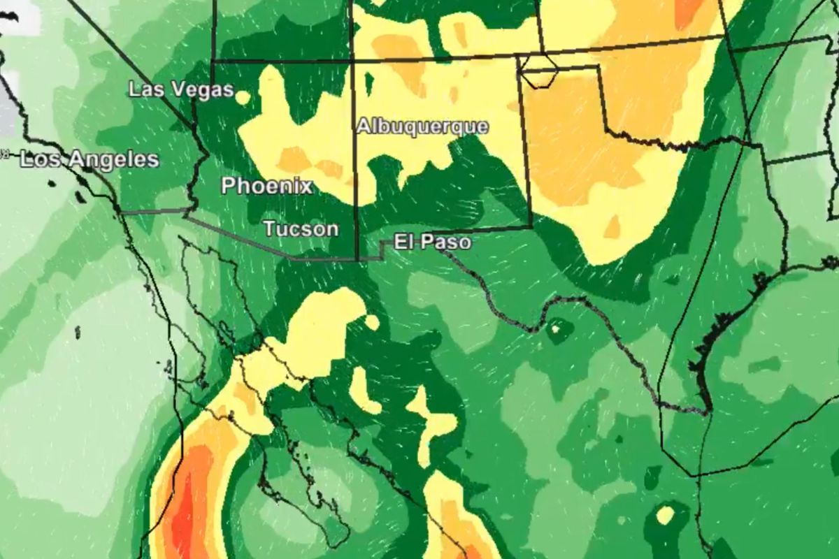
Three hurricanes—Polo, Nolo and Odalys—are currently active in the Pacific Ocean with the National Hurricane Center (NHC) predicting the storms could contribute to “a heavy rainfall and flash flood threat” in the southwestern United States this weekend and into next week.
A map published by the National Weather Service (NWS) branch in Pheonix, Arizona, shows how the probability of heavy rainfall increases dramatically over Wednesday and Thursday in Arizona, New Mexico, northern Texas and into Oklahoma, Colorado and Kansas.
In an accompanying post the NWS Phoenix branch wrote: “Here is a model projection of how a weather system will interact with deep moisture from Hurricanes (Polo and Odalys) to potentially bring widespread heavy rain to much of the Desert Southwest early next week. This will lead to a heightened risk for flash flooding.”
According to the NHC, Hurricane Polo is expected to make landfall in Baja California Sur, Mexico, early next week with the possibility of “life-threatening flooding and mudslides” from Sunday onwards.
The agency also forecasts Polo to produce “dangerous surf and rip currents” along “portions of the northwest coast of Mexico and Baja California for the next few days.”
As of 8 a.m. ET on Saturday the NHC reported Polo had maximum sustained wind speeds of 155 miles per hour, making it a category four hurricane, and was heading west-northwest at around nine miles per hour.
To the west, and slightly to the north, of Polo Hurricane Odalys currently has maximum sustained winds of 105 miles per hour, and is heading north at seven miles per hour, according to the NHC.
The NHC predicts southern swells from Odalys will also impact the southwestern U.S. through the middle of next week, likely overlapping with the impact from Hurricane Polo.
The Pacific has recorded an unusual number of hurricanes this year due to the El Niño climate pattern, which has caused water temperatures in the Pacific near the equator to increase creating the perfect conditions for hurricanes.
Further west still the NHC reports Hurricane Nolo, with a sustained wind speed of 105 miles per hour, is situated to the south of Hawaii. This has resulted in tropical storm conditions, with hurricane conditions possible later today particularly in areas of steep terrain.
Nolo was upgraded to a hurricane by the NHC on Thursday night matching forecasts it would strengthen.
The federal agency forecast “periods of heavy rain” across the Big Island and eastern Maui over the weekend, potentially leading to “significant, life-threatening flooding and mudslides” especially in steep southern and eastern areas. Powerful gusty winds are expected across the Hawaiian Islands as the weekend progresses.
On the other side of the country the National Weather Service’s Weather Prediction Center is forecasting a “strong Nor’easter,” meaning a powerful storm along the North American East Coast over the weekend.
The center said it expects the storm to “rapidly intensify off the Mid-Atlantic Coast on Saturday” before heading towards the New Jersey coast on late Saturday and Sunday.
Residents are warned to expect “major coastal flooding to the Mid-Atlantic Coast over multiple high tide cycles through the weekend” where low-lying areas could see roads submerged and homes and businesses impacted in Southern New England and the Carolinas.
The Nor'easter is expected to bring “gale-force winds to much of the U.S. East Coast” with gusts of 45-65 miles per hour risking power outages for Eastern Long Island and Southwestern New England.