Map Shows States Most Exposed to El Niño Flood Risk - Newsweek
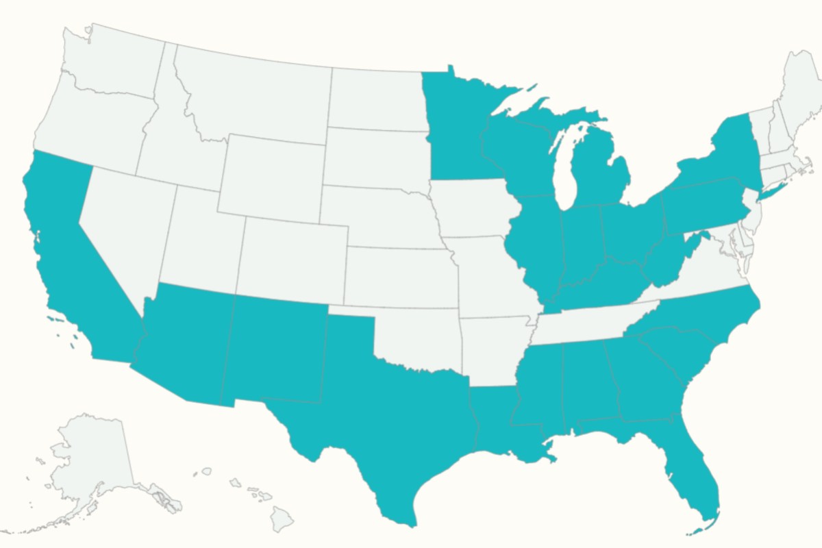
A “soon-to-be historic” El Niño event could increase flood risk across multiple regions of the United States in the coming months, according to weather experts.
Meteorologists told Newsweek that the clearest increase in flood risk is expected across California and the southern tier of the U.S., with the threat generally peaking during the winter.
El Niño is a naturally recurring climate pattern associated with warmer waters in the Pacific and is known to influence temperatures and rainfall worldwide.
The ongoing El Niño, which has already broken records and expected by federal forecasters to strengthen further through the end of the year, could also reach historic strength during the October-December period.
https://public.flourish.studio/visualisation/30367199/
Heather Zons, a meteorologist and principal weather producer at The Weather Channel, told Newsweek that El Niño amplifies the subtropical jet stream, contributing to above-average rainfall from Southern California to Florida. She identified the Southwest and South Florida as areas of concern from January through March.
Arizona and New Mexico could be especially vulnerable because mountains, canyons and steep slopes can rapidly channel water into communities and roads, Zons suggested.
“We could very easily see rushing water overwhelm dry washes and significantly impact neighborhoods and roads,” she said.
South Florida faces a different problem.
“Their sandy soil is perfectly equipped to handle rainfall, however with more and more development on top of those soils, the water has less and less places to go,” increasing the prospect of nuisance flooding, Zons added.
Fox Weather meteorologists Ian Oliver and Greg Diamond also pointed to California and the southern U.S., telling Newsweek that a stronger-than-normal southern branch of the jet stream could generate more storm systems and increase the threat of flooding rain and severe thunderstorms.
They added that the pattern could also raise the potential for flooding and severe weather in the Southeast, with conditions beginning to emerge in the fall and peaking during winter.
“With the soon-to-be historic strength of this El Niño, this could be a cold season full of high impact weather events,” they said.
Jane Minar, another Fox weather meteorologist, told Newsweek that California and states along the Gulf Coast usually face a higher flooding risk during an El Niño winter.
“There is a signal suggesting that January and February could bring a wetter pattern, which would enhance the flood potential for Florida and the Carolinas, along with California,” Minar said.
Zons also identified the Great Lakes and Ohio Valley as areas to monitor after previous periods of heavy rainfall, suggesting that milder El Niño conditions could mean a greater share of winter precipitation falls as rain rather than snow.
Contact Newsweek editors on this story: Ben Kelly and Dave Siminoff.