New land formations linked to Anak Krakatau eruptions - Bangkok Post
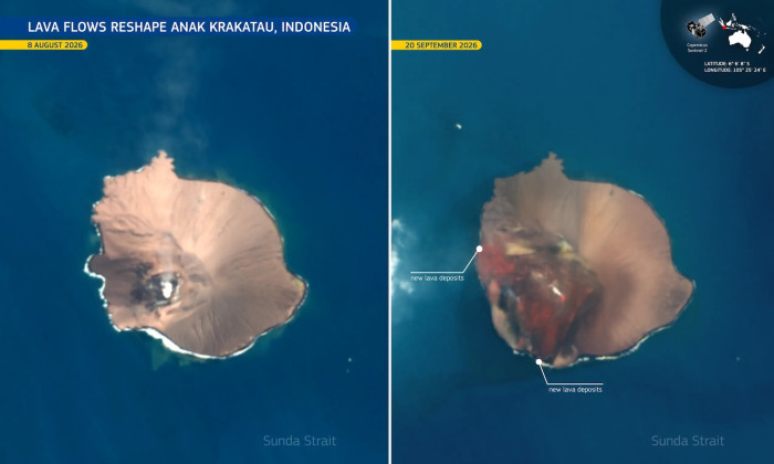
Comparison photos from satellite imagery taken in August and September show new “lava deposits” (right) that followed the Anak Krakatau eruption. (Photo: European Union Copernicus Sentinel-2) JAKARTA - Anak Krakatau volcano in Indonesia expanded by 81 acres (33 hectares) after recent eruptions produced lava flows, while satellite imagery detected two new land formations nearby, the country’s Geology Agency said.
The increase was identified by comparing satellite images from Aug 8 and Sept 15, the agency said in a social media post.
Some media reports have described the new formations as “islands”, but experts say it is too early to know if the features will become permanent or wash away over time due to ocean tides and erosion.
Anak Krakatau erupted for 25 hours from Sept 4 to 6, sending lava towards the northwest, west and southwest.
Sentinel satellite imagery from Sept 20 showed a new formation about 760 metres northwest of Anak Krakatau’s coastline and another about 495 metres to the southeast.
The two formations, on either side of the volcano’s crater, may be linked to the eruptions, the agency said. More recent data and further analysis are needed to determine whether they were new eruption centres, it said.
The eruptions sent ash over Jakarta and surrounding areas, caused several airports to be closed, affecting more than 340,000 travellers, with 2,961 flights cancelled, delayed or diverted. (Story continues below)
Mount Anak Krakatau spews hot lava as seen from Pasauran village in Serang, Banten province, Indonesia, on Sept 5, 2026. (Photo: Reuters)
Anak Krakatau is one of about 130 active volcanoes in Indonesia, which straddles the “Pacific Ring of Fire”, a highly seismically active zone where different plates on the earth’s crust meet to create a large number of earthquakes and volcanic eruptions.
Anak Krakatau, which means child of Krakatau, began emerging a century ago from the area previously occupied by Krakatau, then known as Krakatoa.
The older volcano destroyed itself in mass eruptions in 1883, which killed more than 36,000 people after triggering a series of tsunamis. Heavy ash falls were reported as far as 6,100 kilometres away.
Fine ash particles and sulphur dioxide from the cataclysmic event entered the stratosphere, forming an “equatorial smoke stream” that circled the Earth within weeks.
The dust travelled completely around the planet, causing vivid red sunsets, blue/green suns, and a glowing halo visible across Europe, America and Asia for up to three years.