Satellite captures unbelievable picture: 8 storms raging in oceans at once
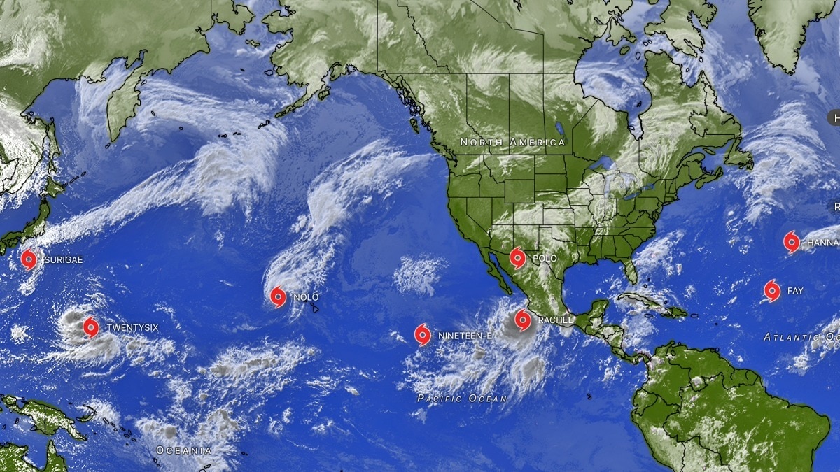
Far from India's shores, the world's tropical oceans are showing a glaring contrast as September draws to a close.
As of September 29, forecasters were monitoring several active tropical systems across the Atlantic and Pacific, including tropical storms, hurricanes and developing disturbances.
The Atlantic remains unusually subdued, while the Pacific has seen bursts of activity.
The difference is particularly underwhelming at a time of year when tropical cyclone activity is typically high. Eight tropical systems are currently active across the Atlantic and PacificTwo tropical storms, Hanna and Fay, are active in the Atlantic. Both are weakening and are likely to dissipate over the next few days. The Atlantic hurricane season remains exceptionally inactive. No pic.twitter.com/ST4R6awnCl— Windy.com (@Windycom) September 29, 2026
The Atlantic season has been remarkably weak so far.
On September 29, the US National Hurricane Center (NHC) was issuing advisories for two tropical storms, Fay and Hanna.
Fay was located well west-southwest of the Azores, while Hanna was far east-northeast of Bermuda.
Hanna had maximum sustained winds of about 75 kmph and was moving east-southeast over the open Atlantic. Fay, meanwhile, had regained tropical-storm strength after weakening earlier.The strong #noreaster off the Mid-Atlantic and Northeast is continuing to bring coastal flooding, rip currents, strong wind gusts and heavy rain to the region. The storm—which is expected to weaken tonight—can be seen in imagery from @NOAA's #GOESEast (#GOES19) this morning. pic.twitter.com/oUaKLRiiaX— NOAA Satellites (@NOAASatellites) September 28, 2026
The season's eight named storms have so far produced no hurricanes.
NHC data show the Atlantic's accumulated cyclone energy was about 90% below the 1991–2020 average as of September 26.
The Pacific has been far more active.
Hurricane Nolo was a major hurricane near the northwestern Hawaiian Islands, with winds reaching about 230 kmph on September 28.
Hurricane Polo, meanwhile, made landfall in Baja California Sur on September 29 with winds of around 175 kmph, bringing life-threatening winds and flash flooding. Satellites in space captured multiple storms churning in the Pacific. (Photo: X/@sen)
Tropical Storm Rachel was moving west-northwest parallel to southwestern Mexico, with winds of about 95 kmph and forecasts calling for further strengthening.
Another disturbance east-southeast of Hawaii also had a high chance of developing, although it was expected to remain well away from the islands.
Typhoon Surigae was meanwhile tracking towards Japan, adding to the busy picture across the western Pacific.IS EL NINO DRIVING THE DIVIDE?
El Nino is an important part of the background pattern, but the situation is more complicated than simply calling it the cause of every storm.
The WMO had forecast a rapid strengthening towards a strong El Nino during July-September 2026.Tropical Storm Hanna and Tropical Depression Fay to its south swirl over the Central Atlantic Ocean. pic.twitter.com/EHvUmkLEss— CIRA (@CIRA_CSU) September 29, 2026
El Nino can suppress Atlantic hurricane activity by increasing upper-level winds, or wind shear, that can disrupt developing tropical systems.
At the same time, changes in atmospheric and ocean conditions across the Pacific can support tropical cyclone development in some areas.
So, while El Nino helps explain the polar opposite environments, the current Pacific surge and Atlantic lull are the result of several interacting oceanic and atmospheric factors and not one climate signal alone.- Ends