Tropical Storm Surigae set to enter PAR on September 24 - Rappler
Already have Rappler+? Sign in to listen to groundbreaking journalism.
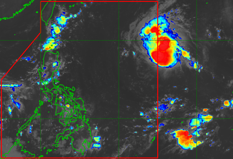
TROPICAL CYCLONE. Satellite image of Tropical Storm Surigae outside the Philippine Area of Responsibility as of September 24, 2026, 3 am.
This is AI-generated. Read the article for full context. Report any errors.
MANILA, Philippines – A tropical cyclone outside the Philippine Area of Responsibility is expected to enter PAR by Thursday morning, September 24, and become the country’s first storm for the month.
It intensified from a tropical depression into a tropical storm on Wednesday evening, September 23, and was given the international name Surigae — a name contributed by North Korea that refers to a type of eagle.
The tropical cyclone had developed from a low pressure area outside PAR last Tuesday, September 22.
In a briefing past 5 am on Thursday, the Philippine Atmospheric, Geophysical, and Astronomical Services Administration (PAGASA) said Surigae was located 1,500 kilometers east of Northern Luzon as of 3 am.
The tropical storm is moving west northwest toward PAR at a relatively fast 30 kilometers per hour, with maximum sustained winds of 75 km/h and gustiness of up to 90 km/h.
Once it enters PAR, it will be given the local name Queenie.
According to PAGASA, the future Queenie is projected to continue its west northwestward movement until Friday, September 25, then start turning northwest on Saturday, September 26, and north by Monday, September 28.
The tropical cyclone is also expected to strengthen further in the coming days, and may eventually reach typhoon status by Sunday, September 27.
Fortunately, Surigae is unlikely to make landfall in the Philippines, and it is not expected to directly affect weather conditions in the next three days, according to PAGASA.
It is also not seen to enhance the southwest monsoon or habagat.
Although the chances of direct impact are slim, Surigae’s trough or extension has been affecting parts of the country.
On Thursday, Biliran, Leyte, Southern Leyte, Dinagat Islands, Surigao del Norte, and Surigao del Sur will have scattered rain and thunderstorms due to the trough of the tropical storm, while the rest of Eastern Visayas as well as Bicol may see isolated rain showers or thunderstorms. Flash floods and landslides are possible.
The rest of the country — not affected by Surigae’s trough — could just have localized thunderstorms on Thursday.
PAGASA added that the eastern seaboard of Northern Luzon will have moderate waters beginning Saturday, when Surigae would be around 600 to 700 kilometers away from the country’s northernmost province of Batanes. – Rappler.com