
Two monsoon systems pummeling India: Satellite captures weather whiplash
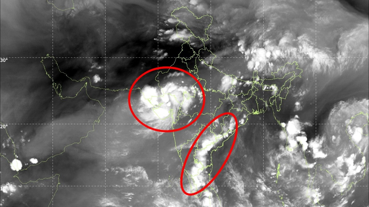
India is witnessing a striking weather contrast from space as two active monsoon systems continue to influence rainfall across different parts of the country, while signs of the season's gradual withdrawal are beginning to emerge.
A fresh satellite image from the INSAT-3DS weather satellite shows extensive cloud formations stretching across western, central and southern India, highlighting the continued influence of the Southwest Monsoon even as atmospheric patterns begin to shift.
The most significant rainfall activity is currently centred over Gujarat, south Rajasthan and western Madhya Pradesh, where a major monsoon system is delivering one of the final widespread spells of heavy rain for the region this season.
According to weather assessments, this could be the last major monsoon rainfall episode over Gujarat, south Rajasthan and western Madhya Pradesh before a significant reduction in rainfall sets in.
The reason lies in a changing atmospheric pattern.
An anticyclone, a large region of high pressure associated with sinking air and generally drier conditions, is expected to develop over the region by the end of this week. Its formation could suppress cloud development and accelerate the decline of monsoon rainfall across parts of northwestern and central India.
At the same time, another unusual pattern is visible over southern India. Massive weather activity seen over Western and Southern India. (Photo: IMD)
The satellite imagery shows clusters of thunderstorms developing across the peninsula, a pattern more commonly seen during April and May, before the arrival of the Southwest Monsoon. During the peak monsoon season, southern India is typically influenced by a more organised and persistent monsoon flow.
The emergence of these scattered thunderstorm clusters suggests that the broader monsoon circulation may be gradually returning to its pre-onset conditions, a possible indication that the withdrawal phase is drawing closer.
Meanwhile, weather systems over India's surrounding seas continue to remain active.
Over the Arabian Sea, unsettled weather is expected along and off the Gujarat coast and adjoining northeast Arabian Sea until September 16. Activity is also likely along the north Maharashtra coast and parts of the Comorin area off south Kerala.
Over the Bay of Bengal, weather activity is expected across parts of the southeast and southwest Bay between September 15 and 19, with conditions also remaining active over the Andaman Sea from September 16 to 19.
The contrasting weather systems underline the changing nature of India's monsoon transition.
While parts of western and central India receive one final major burst of rain, southern India is already beginning to show atmospheric patterns associated with the changing season.
From space, the message is clear: the monsoon still has some punch left—but its long retreat may finally be getting underway.- EndsPublished By: Sibu Kumar TripathiPublished On: Sep 14, 2026 19:30 IST
